Salmon Creek Dam & Reservoir Trail
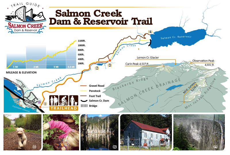
The trail begins as a gentle-sloping gravel road which rolls along for about two miles through an emerald mountain valley. Off to the side, Salmon Creek tumbles its way toward the sea.
Just short of AEL&P’s old upper powerhouse, a signpost directs hikers off the road and onto a more traditional Southeast trail. For about a half mile your path will roughly parallel the penstock, catching a glimpse here and there of the huge water conduit. Keep looking up, however, as the face of the dam will peek through the trees as you near its base. The contrast between hemlock green, man-made gray and azure blue is striking. Close to the base, the trail takes a left turn and begins a short, yet steep ascent to the top. The view of the large reservoir, surrounded by towering mountains, is the hiker’s reward.

Trail Information and Details:
- Length: 3.5 miles, round trip 5-6 hours. Recommended season: Spring, summer and early fall.
- Elevation gain: 1,100 feet
- Difficulty: Lower Section: Easy; Upper Section: More difficult, not recommended for small children.
- Condition (Lower Section): Excellent. The road is maintained by AEL&P. (Upper Section): Good. Do not use the penstock, as it is extremely hazardous.
- Special Features: There is fishing for eastern brook trout in the reservoir. During the summer the salmon berries and blueberries are ready to pick and eat.
- Access: When driving north from Juneau, turn right just past the cement abutment at mile 2.5 of Egan Drive. The turnoff is accessed from the north bound lane only and is located after the Salmon Creek Powerhouse. Public admittance is restricted to foot traffic only.
The Salmon Creek Hydroelectric Project is owned and operated by AEL&P. For the printable PDF brochure click the link below or pick one up at our Lemon Creek office.
